Leeds City Council are carrying out an extensive redesign of the Transport System in and around the centre of Leeds. The redesign includes new bus-lanes, pedestrian footways, cycle-ways and a re-prioritisation of traffic routes.
John Sisk have been contracted to carry out the construction work and full Underground Utility Surveys were required prior to any works been carried out.
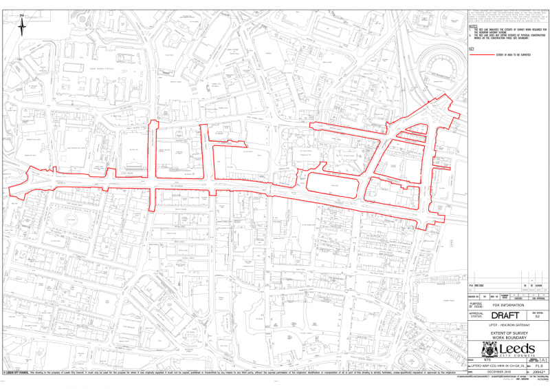
The survey works centre around the Headrow, which is the main street in the centre of Leeds where the Town Hall is located. The surveys were required for all the main streets including the highways and the footpaths. The centre of Leeds is extremely busy with vehicles and pedestrians and the survey area included bus lanes, taxi ranks, one-way streets and multiple traffic signaled junctions. All these elements presented a major challenge when it came to accessing the highways for surveying purposes and we knew that the Traffic Management design would be critical.
The area of survey is detailed below:
02
40Seven Solution
Knowing how critical the Traffic Management would be to the survey programme prompted us to arrange a pre-tender meeting between Leeds City Council’s Traffic Department, ourselves and our Traffic Management supplier to discuss the practicalities of the scheme. This proved highly beneficial to us, as we were able to fully understand the diversions that would be required, the areas that we would be able to control each shift and which roads could be surveyed under lane closures and which would need to be surveyed under full road closures. This was critical to us designing a programme of works that would take in to account the lead-in times for permits and also how many survey teams we would allocate to different sections of the survey. For instance, the central Headrow area itself had to be surveyed under full road closures, which required 8-weeks’ notice for the permit approval and then to maximise utilisation of the closure, we planned for an 8-person survey team to complete all the work in a 5-night shift window.
Due to the nature of the environment, we carried out all the survey works during weekday night time shifts (Sunday to Thursday), where we commenced work on the footpaths at 8pm until the Traffic Management was installed at 11:30pm once all the buses had stopped running. We then commenced surveying in the highway until 4am when the Traffic Management was removed.
Leeds Town Hall
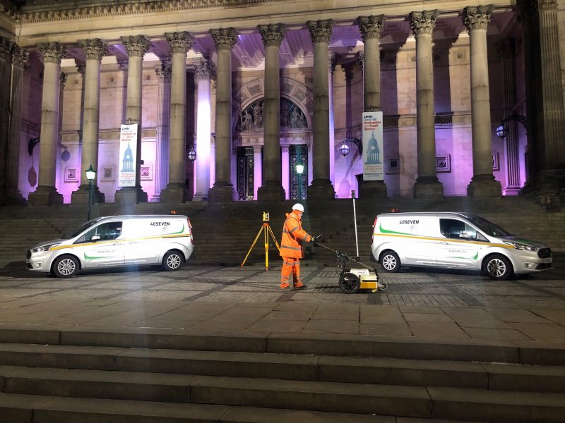
The survey was carried out to PAS128 M4P specification which required full coverage GPR data to be collected and all surveyed marks to be positioned topographically. The GPR survey was carried out using our mobile Multi-Array GPR unit mounted to a 4-wheel drive vehicle, which allowed us to collect all the data quickly and accurately. The Electro-Magnetic data was surveyed using RD8000 Transmitters and Receivers, with the surveyed locations being marked on the ground using temporary spray paint. All the positions were then surveyed Topographically using Trimble Total Stations. The surveyed data was then transferred to the office following each shift to be processed on a rolling programme throughout the project.
The total length of the survey programme was 13 weeks, followed by 3 weeks to complete and Quality Check the final data. The client was keen to progress with the design works quickly and required the survey information as soon as possible, so we processed the data throughout the duration of the survey and delivered the most critical sections in stages throughout the programme. Shift reports were issued to the client following each shift detailing the personnel who were on site, the area surveyed and any issues that we had encountered. Considering we were working in a busy city centre, we had very few issues bar the occasional drunk and hypodermic needles found in inspection chambers. Needles were reported within the shift report with a photo and location and the client arranged for them to be removed so that we could revisit them and survey them safely.
The post processing of the radar data was undertaken by the GPR Surveyor using dedicated software with each utility located in position and depth. The Electro-Magnetic data was processed by the Land Surveyor and all the utility information was then overlaid on to the existing topographical survey to compare the GPR positions with the Electro-Magnetic positions and the surface covers and features. The C2 desktop stats for the whole area were provided by the client and these were cross checked against the surveyed data to ensure that all services had been located. If there were services that had not been located within the survey data, then this information was added to the drawing as record information in a separate layer and line-type.
03
The Results
All of the underground utility survey information was overlaid on to the existing topographical survey and the quality levels were then added to each line-type as per PAS128. A utility report was then issued detailing the findings in each area with the final deliverable for the project being 3D AutoCAD drawings with PDF versions.
Once we had completed and delivered the Headrow Survey, we were asked to provide a proposal for the Corn Exchange, which was next stage of the Transport Scheme. We commenced this survey in November 2019 to the same specification and we will deliver the completed survey to plan in February 2020. The area of survey can be seen in the plan below.
Industry-leading surveying services, delivering the right data at the right time.
We use cookies to ensure that we give you the best experience on our website. If you continue to use this site we will assume that you are happy with it.Ok